We are expecting heavy precipitation tonight and throughout the next few days, and our area will be under “Flood Watch” Saturday night through Monday morning. Current situation: In particular, I spoke with FIIP today, and the reservoirs in the Mission Mountains are nearing or at full pool. FIIP is doing their best to flush excess water storage, but it could affect the drainage area. The current discharge (at cubic feet per second) is nearing historic levels last seen in 2020, meaning Mission and Post Creeks may both experience flooding, and local residents as well as Highway 93 traffic could be impacted. But, it is hard to predict how much flooding will occur, as it depends greatly on how much rainfall these storms actually bring. DEWR is closely involved with the developing outflow. It is also worth noting that the Flathead River up by Columbia Falls is projected to reach a potential “action stage” of minor flooding, as well. Nearby residents have been notified: The following message was pushed this evening by Lake County HYPER-REACH to residents, who live in the vicinity of Mission and Post Creeks and are registered for the county’s emergency alert notification system: “Area residents that live along Post Creek and Mission Creek are being advised of possible flooding in those areas from melting snow and projected rain. Please prepare your property if you are normally affected by flooding. Do not drive through any roads that are under water. Flathead Irrigation is monitoring the canals and flow rates released. This is a message from the Lake County Office of Emergency Management.” Precautionary measures: I’ve spoken with the fire chiefs at St. Ignatius, Ronan, and Charlo-Moiese, whose departments are assessing their sandbag inventory, should those become necessary. Tammy Matt with Tribal Health did a wonderful job working with Elder Services’ Diane Matt on gathering elders’ information in the flood-potential area of those two creeks, should we need to coordinate with them further.
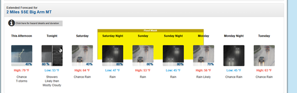
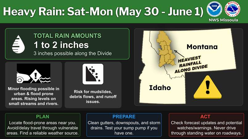
We will continue to closely monitor this situation. There are two National Weather Service (NWS) graphics for your reference below. Please let me know if you have questions.